Thursday, June 21, 2007

Day 18 (6/16), Bannock State Park to Virginia City ~81 miles

We climbed Beaver Pass to start the day. The view on the way down showed

hazy mountains which were amazing. It was a nice day until it started to thunder, which made a nice view of the clouds at the end of the day. We saw a hawk with a fish in its talons.


Day 17 6/15/07, Sula, MT to Bannock, MT ~78 miles


We climbed to start the day and crossed the Continental Divide for the first time at Chief Joseph Pass. After the pass the downhill had a strong headwind, so we didn't quite fly down as we had hoped. On the other side of the pass we were in Big Hole Valley, which is also known as the land of 10,000 Haystacks. At first I thought it said Mistakes, but on closer look it was haystacks, and it's grazing country and there are quite a few haystacks. At least 7,000 but I'm sure they rounded up.
They day was, "OK" as the barn roof said, it was sunny but a lot of wind and by the end of it I was exhausted and ready for bed.

In Wisdom, MT I saw a drill rig, but they told me they were drilling for oil when I asked. I said that's not an oil rig and then they told me it was a well, so we finally got that straightened out.

We had to climb up Big Hole pass to end the day and on the downside I blew a flat, not too bad for my first flat on the trip. Luckily it was only a soft flat on my rear wheel because we were flying down that hill at 30mph.

Day 16 (6/14/07), Lolo, MT to Sula, MT ~79 miles

It was a beautiful day, but most days are when you're biking across new and interesting country. In Darby, MT a truck was pulling along us like he was going to pass, but instead he slowed down and the passenger door opened and the passenger started throwing up. Luckily, i was just far enough away not to get any on me, but it creeped me out and it was gross! The rest of the ride we saw the Bitteroot Mountains which were snowed capped peaks and less gross and disturbing images. Right before Sula, MT we saw a whole herd of what looked like mountain goats, or some sort of sheep, but I'll let Katherine D. figure it out for me, she's the one who raises goats. There were like 20 of them and they let us get pretty close (not really by choice, but they were practically standing in the road and we needed the road to get by). We did an extra 6.5 miles past Sula to start out tomorrow's climb early because that is our first crossing of the Continental Divide.

Tuesday, June 12, 2007

Montana!

Day 14 (6/12/07) Jerry Johnson Campground, Idaho to Lolo, Montana, only ~58 miles today, but a pretty major climb up to Lolo Pass which separates Idaho from Montana. Good weather, but I was definitely stiff from the century yesterday. My legs felt a bit like lead, but that helped on the downhill from Lolo Pass to Lolo, Montana about 34 miles of downhill or slightly downhill and we had a tailwind and cruised on in to Lolo at about 20 miles per hour without really trying. It was nice! We sagged into Missoula, MT and checked out Adventure Cycling the organization that puts out the Transamerica route maps (and lots of other routes throughout the US and Canada). They were really nice, they gave us cold drinks and took our pictures. It was really fun. Now I'm staying at the KOA in Missoula, while Skip and Cydna are out to dinner for their 25th anniversary! Tomorrow we're taking a rest day and hopefully checking out a bike shop and just hanging out around Missoula. Then we're off and in a week or so we should be in Yellowstone for two rest days to check out both Yellowstone and the Tetons! I'm surprised that we've gone over 950 miles total and we've made it to our third state! It's been an amazing experience to see the country at a slower pace. I've actually learned quite a bit of history surrounding the areas we've ridden through. We rode past Fort Fizzle (Fo Shizzle) and we've been on the Lewis and Clark trail. Hope everyone is having a good summer!

IDAHO...no you da HO


Day 13 (6/11/07): Grangeville, Idaho to Jerry Johnson campground, Idaho 103 miles! This was my first 100+ mile day! The weather was perfect, and the river along Route 12 was beautiful, there was Clearwater, Lochsa and one other one they were great. It was a very very long day but I was pumped we made it and we had a nice bottle of wine at the end to celebrate!


Day 12 (6/10/07): New Meadows, Idaho to Grangeville, Idaho. 83 miles in the rain! Pouring, relentless, cold rain. There were no pictures today. Today was the day of near-misses! Two dogs attacked us, I almost hit the one who went after Skips back wheel and the other went after my rear tire! Skip got run off the road, because there was no shoulder and lots of fast moving logging trucks. There was a 12+ mile steep climb (crazy switchbacks) up Whitebird pass, where it was so foggy we missed our SAG and ended up riding down freezing without visibility in the rain to our campground. We were worried and cold and the very nice owner of the campground let me take a hot shower and let me borrow a towel...he was awesome!


Day 11 (6/9/07): Brownee Dam, Idaho to New Meadows, Idaho ~72 miles.

Nice weather but a 9 mile climb to start of the day was a bit rough. Then a couple shorter climbs during the day made it a long day. New Meadows had a nice little bike shop and an A&W rootbeer which we had some nice burgers and root beer after the ride. Once again, the scenery was beautiful, we saw the largest deer so far with large velvety racks, they crossed and recrossed the road in front of us!


Day 10 (6/8/07): Baker City, Oregon to Brownee Dam, Idaho ~85 miles. Cool in the morning, a 7 mile climb before lunch and just after Richland, Oregon. My new computer reset itself and so I don't have an accurate mileage, but it was around 85 miles. The ride itself was once again pretty and went past some huge hydro electric dams near Hell's Canyon. We saw some deer cross the road and half a dozen brown sheep grazing, although I thought they looked more like goats.


Thursday, June 7, 2007

Oregon Trail....

Day 9 (6/7/07): Baker City-REST DAY! Today was our first rest day and it was much needed. WE went shopping and I got some stuff fixed at the bike shop and did laundry. It was nice to not have to bicycle today, but we'll be heading into Idaho tomorrow, so it should be fun to go into a different state! Oregon was beautiful, but I've heard good things about Idaho too. I'm not sure we'll have any more internet access until Missoula, MT, so until then, Happy trails!

Day 8 (6/6/07): Prairie City, OR to Baker City, OR: ~68 miles. Three 7 mile climbs over 3 pretty high (5000ft+) passes, it was another cold day. It was snowing up two of the three passes. Once again, no pictures, and we finished with a strong headwind through Baker City.

Day 7 (6/5/07): Dayville, OR to Prairie City, OR: 45 mile day. I took NO pictures today because it was about 48 degrees and rainy. Luckily it was a short day, but we were soaked and cold and my computer broke so I had no idea how far I'd gone. It was the first bad day, so I can't complain too much. Cydna got the RV in a bit of an accident at the RV park so we had to stand out in the rain a little more, but it involved a tow truck and the Prairie City water department...
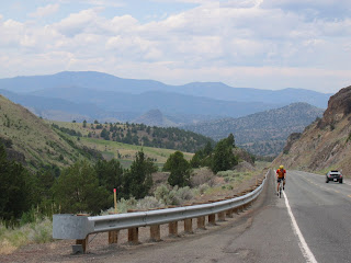

Day 6 (6/4/07): Prineville, OR to Dayville, OR:
86.5 mile day. Two passes to climb the Ochoco pass, which was a 30 mile slight grade, and a drop into Mitchell, OR and then a steep and hot 7 mile climb to the Keyes pass. Then a 35 mile downhill along a creek into Dayville. The downhill was through what looked like canyons in the beautiful basalt. We saw deer today on each side of the passes.
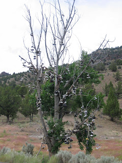
I'm not sure why, but it seems to be popular in Eastern Oregon to throw shoes in a tree, I thought they were mushrooms at first, but they were nice shoes, probably not even worn all the way out! I kept my shoes on, however, earlier in the day I had problems and my cleat lost 3 of the four screws attaching it to my shoe (insert joke about screws loose here...). Luckily I'm wicked handy and was able to fix it, but I'll have to find more screws soon.
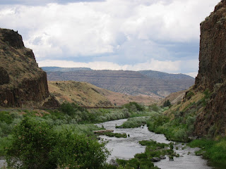


We biked by John Day Fossil beds where they once filled trainloads with fossils. Dayville is another small town, approx. 130 people. WE saw Steve again and had dinner with him and I had a creamcicle from the Dayville Mercantile for desert.
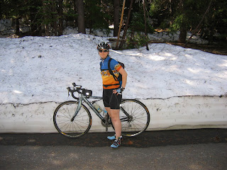


Day 5 (6/3/07): McKenzie Bridge, OR to Prineville, OR


68 mile day started off with the remaining climb to the top of McKenzie pass. IT was spectacular! The road itself was closed to vehicular traffic, only cyclists and pedestrians could be on it for a two week period, so we lucked out! There is still snow on the pass, and near the top there are tons a basalt lava flows ~300-400 years old, so relatively new! At the top there were 360 degree views of snow capped peaks. We could see two of the three Sisters, Mt. Washington and Mt. Jefferson and ever-so-faintly Mt. Hood. WE met a local cyclist who acted as our tour guide which was really nice of him.
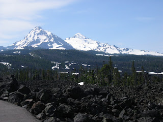


On the other side of the pass the terrain was dramatically different-it was arid and hot. I guess this is the Oregon desert. It was amazing how quickly the terrain and climate changed in a few miles!

Oregon Trail...


Day 4 (6/2/07): Coburg, OR to McKenzie Bridge, OR: 72 miles of riding. The day was gorgeous and we rode part of the day with Keith (shown in the picture). The first 60 miles or so were a slight gradient but it felt pretty flat with a tailwind. The last 11 miles involved climbing a steep grade to the gate at McKenzie pass. We stopped at the gate because it was getting late in the day and there were isolated thunderstorms.


Day 3 (6/1/07): Grand Ronde to Coburg, OR:


80 miles of riding today. The riding had a few smaller (3-5 mile) climbs in the morning but was relatively flat for the rest of the day through the Willamette Valley. I saw my first drill rig outside of Monmouth, OR, unfortunately it was un-manned and only a water rig... We met up with a couple other cyclists in Coburg, which is outside of Eugene. One was just finishing up the Transamerica route, he was headed to Astoria, OR from Yorktown, VA. Keith, originally from Bow, NH and more recently Brighton, Utah wasn't following a specific route, but towing a 90 pound trailer and headed to Portland, Maine via both the Transamerica route, the Northern Tier route and whatever other route he had in his head. Steve, started from Seattle and was using panniers and heading to Yorktown as well.


Right before our campground in Coburg I saw the sketchiest van EVER. It was a fifteen passenger van with a large cardboard sign that said "FREE CANDY", and at first I was tempted by the candy, but as soon as I started moving toward the van I thought about all the 60 minute episodes and was able to stop myself.


Day 2: Netarts, Oregon to Grand Ronde, Oregon:


Netarts is on the coast and we biked along the coast for 20 or so miles and then headed inland to Grand Ronde, supposedly home to the largest casino in Oregon. The ride was 67 miles. The terrain changed as we moved away from the coast and the traffic was heavy with large logging trucks on roads with little to no shoulder. I was scared for my life more than one time, but happy to end the day in one piece.